June 14 - 17, 1988
Click on the site to retrieve information.
|
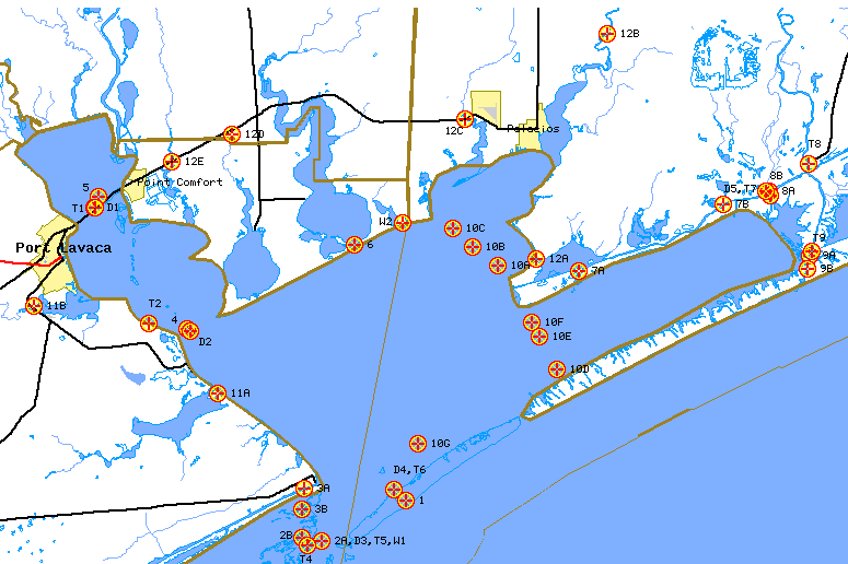
| 1988 Matagorda Bay Field Study | ||||||||
| Name | Site | Latitude (N) | Longitude (W) | Datasonde Quality | Manual Quality | Point Velocity | Tides | Wind |
| Text files of raw data for entire study | X | X | X | X | X | |||
| Matagorda Entrance Channel | 1 | 28° 25.73' | 96° 19.45' | 1 | ||||
| Line Site 397-2 (Ancillary) | 1A | 28° 25.27' | 96° 19.38' | 1A | ||||
| Pass Cavallo | 2A,D3,T5,W1 | 28° 23.92' | 96° 23.87' | 2A | ||||
| Saluria Bayou | 2B | 28° 24.07' | 96° 24.88' | 2B | ||||
| (ICWW) Port O'Connor | 3A | 28° 26.28' | 96° 24.75' | 3A | ||||
| Big Bayou | 3B, T3 | 28° 25.37' | 96° 24.87' | 3B | ||||
| Indian Pt to Sandy Pt | 4 | 28° 33.60' | 96° 30.83' | 4 | ||||
| Line Site 150-2 | 4A | 28° 36.28' | 96° 31.93' | 4A | ||||
| Line Site 150-4 | 4B | 28° 35.37' | 96° 33.42' | 4B | ||||
| Line Site 200-2 | 4C | 28° 30.97' | 96° 26.98' | 4C | ||||
| Line Site 210-2 | 4D | 28° 28.12' | 96° 22.80' | 4D | ||||
| Line Site 375-3 | 4E | 28° 32.55' | 96° 24.68' | 4E | ||||
| Lavaca Bay at SH 35 | 5 | 28° 39.68' | 96° 35.48' | 5 | ||||
| Line Site 85-1 | 5A | 28° 40.58' | 96° 35.20' | 5A | ||||
| Carancahua Pass | 6 | 28° 37.52' | 96° 22.13' | 6 | ||||
| ICWW at Oyster Lake | 7A | 28° 36.30' | 96° 10.45' | 7A | ||||
| ICWW at Hollywood Terminal | 7B | 28° 39.33' | 96° 2.95' | 7B | ||||
| ICWW at Culver Cut | 8A | 28° 39.97' | 96° 0.57' | 8A | ||||
| Culver Cut | 8B | 28° 39.73' | 96° 0.53' | 8B | ||||
| Colorado River blw Parkers Cut | 9A | 28° 36.98' | 95° 58.47' | 9A | ||||
| Parkers Cut | 9B | 28° 36.40' | 95° 58.57' | 9B | ||||
| Line Site 147-2 | 9C | 28° 35.92' | 95° 58.73' | 9C | ||||
| Line Site 300-1 | 10A | 28° 36.57' | 96° 14.70' | 10A | ||||
| Line Site 300-2 | 10B | 28° 37.40' | 96° 16.02' | 10B | ||||
| Line Site 300-3 | 10C | 28° 38.27' | 96° 17.00' | 10C | ||||
| Line Site 350-1 | 10D | 28° 31.75' | 96° 11.62' | 10D | ||||
| Line Site 350-2 | 10E | 28° 33.25' | 96° 12.53' | 10E | ||||
| Line Site 350-3 | 10F | 28° 33.88' | 96° 12.93' | 10F | ||||
| Line Site 375-1 | 10G | 28° 28.33' | 96° 18.85' | 10G | ||||
| Powderhorn Lake | 11A | 28° 30.67' | 96° 29.23' | 11A | ||||
| Chocolate Bayou | 11B | 28° 34.63' | 96° 38.80' | 11B | ||||
| Palacios Bayou | 12A | 28° 36.83' | 96° 12.68' | 12A | ||||
| Tres Palacios River | 12B | 28° 47.15' | 96° 9.00' | 12B | ||||
| Turtle Creek | 12C | 28° 43.23' | 96° 16.38' | 12C | ||||
| Kellers Creek | 12D | 28° 42.57' | 96° 28.55' | 12D | ||||
| Cox's Creek | 12E | 28° 41.32' | 96° 31.68' | 12E | ||||
| Lavaca Causeway | D1 | 28° 39.20' | 96° 35.73' | |||||
| Sandy Point | D2 | 28° 33.50' | 96° 30.67' | |||||
| Range Tower | D4,T6 | 28° 26.25' | 96° 20.08' | |||||
| Culver Cut | D5,T7 | 28° 39.95' | 96° 0.70' | |||||
| Point Comfort | T1 | 28° 39.20' | 96° 35.67' | |||||
| Magnolia Beach | T2 | 28° 33.87' | 96° 32.83' | |||||
| Saluria Bayou | T4 | 28° 23.70' | 96° 24.60' | |||||
| Colorado River near ICWW | T8 | 28° 41.22' | 95° 58.52' | |||||
| Colorado River near Mouth | T9 | 28° 37.22' | 95° 58.37' | |||||
| Palacios | W2 | 28° 38.50' | 96° 19.67' | |||||