|
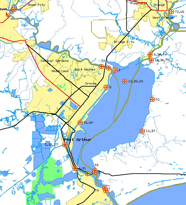
June 1 - 4, 1996 |
|
Click on the site to retrieve information.
|
| 1996 Sabine Lake Field Study | |||||||||||||
| Name | Site | Latitude (N) | Longitude (W) | Point Velocity | ADCP Flow | Manual Quality | Datasonde Quality | Wind | Tides | ||||
| Text files of raw data for entire study | X | X | X | X | X | X | |||||||
| Sabine Pass | 1 | 29° 44.03' | 93° 52.33' | 1 | |||||||||
| Sabine Lake at Hwy 82 | 2 | 29° 46.00' | 93° 53.75' | 2 | |||||||||
| Port Arthur Canal | 3 | 29° 45.83' | 93° 54.75' | 3 | |||||||||
| Keith Lake Fish Pass | 4,D1 | 29° 46.50' | 93° 56.50' | ||||||||||
| GIW at Highway 87 | 5,D2,T7 | 29° 49.33' | 93° 57.92' | 5 | |||||||||
| Sabine Canal | 6 | 29° 56.30' | 93° 52.17' | 6 | |||||||||
| Neches River nr Hwy 87 | 7 | 29° 58.62' | 93° 51.82' | 7 | |||||||||
| GIW at Stewts Island | 8 | 29° 58.37' | 93° 50.90' | 8 | |||||||||
| Sabine River | 9,D4,T4 | 30° 0.25' | 93° 46.00' | 9 |
|
||||||||
| Black Bayou | 10,D6,T5 | 29° 59.58' | 93° 45.83' | 10 | |||||||||
| Three Bayou | 11 | 29° 54.83' | 93° 45.67' | 11 | |||||||||
| Johnson Bayou | 12,D7 | 29° 50.97' | 93° 47.08' | ||||||||||
| Platform A | 13,D3,W3 | 29° 57.03' | 93° 49.55' | 13 | |||||||||
| Beaumont | T1,W1 | 30° 5.70' | 94° 5.00' | ||||||||||
| Orange | T2,W2 | 30° 5.40' | 93° 43.00' | ||||||||||
| Rainbow Bridge | T3 | 29° 58.80' | 93° 52.80' | ||||||||||
| Port Arthur | T6,W4 | 29° 52.00' | 93° 55.80' | ||||||||||
| Mesquite Pass | T8 | 29° 46.20' | 93° 53.70' | ||||||||||
| Sabine Pass | T9 | 29° 43.80' | 93° 52.20' | ||||||||||