April 19 -22, 1988
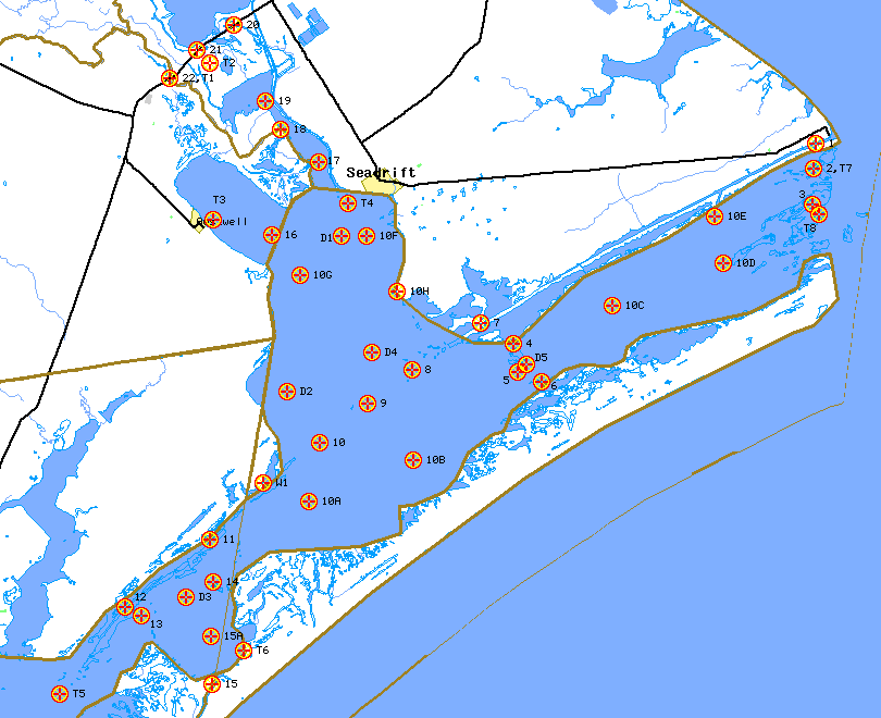
Click on the site to retrieve information.
|
| 1988 San Antonio Bay Field Study | ||||||||
| Name | Site | Latitude (N) | Longitude (W) | Datasonde Quality | Manual Quality | Point Velocity | Tides | Wind |
| Text files of raw data for entire study | X | X | X | X | X | |||
| ICWW at Port O'Connor | 1 | 28° 26.28' | 96° 24.75' | 1 | ||||
| Big Bayou | 2,T7 | 28° 25.37' | 96° 24.87' | 2 | ||||
| Saluria Bayou | 3 | 28° 24.07' | 96° 24.88' | 3 | ||||
| Steamboat Pass | 4 | 28° 18.95' | 96° 37.38' | 4 | ||||
| South Pass | 5 | 28° 17.85' | 96° 37.22' | 5 | ||||
| Pete's Cut | 6 | 28° 17.50' | 96° 36.20' | 6 | ||||
| ICWW at Lake Island | 7 | 28° 19.70' | 96° 38.75' | 7 | ||||
| ICWW at Marker 7 | 8 | 28° 17.95' | 96° 41.63' | 8 | ||||
| ICWW at Marker 17 | 9 | 28° 16.68' | 96° 43.47' | 9 | ||||
| Line Site 294-4 | 10 | 28° 15.25' | 96° 45.47' | 10 | ||||
| Line Site 294-2 | 10A | 28° 13.08' | 96° 45.92' | 10A | ||||
| Line Site 302-2 | 10B | 28° 14.63' | 96° 41.58' | 10B | ||||
| Line Site 342-2 | 10C | 28° 20.35' | 96° 33.25' | 10C | ||||
| Line Site 354-3 | 10D | 28° 21.90' | 96° 28.63' | 10D | ||||
| Line Site 354-5 | 10E | 28° 23.60' | 96° 28.98' | 10E | ||||
| Line Site 264-1 | 10F | 28° 22.88' | 96° 43.55' | 10F | ||||
| Line Site 264-4 | 10G | 28° 21.45' | 96° 46.28' | 10G | ||||
| Line Site 274-1 | 10H | 28° 20.85' | 96° 42.25' | 10H | ||||
| ICWW at Rattlesnake Island | 11 | 28° 11.72' | 96° 50.05' | 11 | ||||
| ICWW at Bludworth Island | 12 | 28° 9.22' | 96° 53.60' | 12 | ||||
| Cedar Dugout | 13 | 28° 8.92' | 96° 52.92' | 13 | ||||
| Ayres Dugout | 14 | 28° 10.13' | 96° 49.90' | 14 | ||||
| Cedar Bayou | 15 | 28° 6.40' | 96° 49.93' | 15 | ||||
| Line Site 314-2 | 15A | 28° 8.17' | 96° 49.98' | 15A | ||||
| Hynes Bay | 16 | 28° 22.93' | 96° 47.48' | 16 | ||||
| Guadalupe Bay | 17 | 28° 25.62' | 96° 45.52' | 17 | ||||
| South Guadalupe River | 18 | 28° 26.82' | 96° 47.13' | 18 | ||||
| Mission Lake | 19 | 28° 27.83' | 96° 47.73' | 19 | ||||
| Goff Bayou at Hwy 35 | 20 | 28° 30.67' | 96° 49.08' | 20 | ||||
| Hog Bayou at Hwy 35 | 21 | 28° 29.75' | 96° 50.63' | 21 | ||||
| Guadalupe River at Hwy 35 | 22,T1 | 28° 28.70' | 96° 51.75' | 22 | ||||
| Seadrift Channel | D1 | 28° 22.88' | 96° 44.55' | |||||
| Mid San Antonio Bay | D2 | 28° 17.15' | 96° 46.83' | |||||
| Mesquite Bay | D3 | 28° 9.60' | 96° 51.07' | |||||
| Panther Reef | D4 | 28° 18.63' | 96° 43.30' | |||||
| South Pass | D5 | 28° 18.13' | 96° 30.83' | |||||
| Schwings Bayou at Hwy 35 | T2 | 28° 29.23' | 96° 50.08' | |||||
| Austwell | T3 | 28° 23.50' | 96° 49.92' | |||||
| Seadrift Channel | T4 | 28° 24.08' | 96° 44.28' | |||||
| Aransas Bay near Dunham Point | T5 | 28° 6.05' | 96° 56.28' | |||||
| Mesquite Bay near Fulton | T6 | 28° 7.65' | 96° 48.62' | |||||
| Saluria Bayou near Port O'Connor | T8 | 28° 23.70' | 96° 24.60' | |||||
| Aransas Wildlife Refuge | W1 | 28° 13.78' | 96° 47.85' | |||||