November 10 - 11, 2001
| Name | Site | Latitude (N) | Longitude (W) | Total Flow | Water Quality | Velocities | |
|---|---|---|---|---|---|---|---|
| GIWW & Brazos River Confluence |
North | 1a | 28° 54.01' | 95° 23.07' | T G | T G | T |
| South | 1b | 28° 53.21' | 95° 23.02' | T G | T G | T | |
| East | 1c | 28° 53.56' | 95° 22.42' | T G | T G | T | |
| West | 1d | 28° 53.53' | 95° 23.33' | T G | T G | T | |
| Center | 1e | 28° 53.35' | 95° 23.06' | Not Available | T G | Not Available | |
| State Highway 36 | 2 | 28° 56.46' | 95° 22.48' | T G | T G | T | |
| Dow Outfall | 3 | 28° 58.39' | 95° 23.09' | T G | T G | T | |
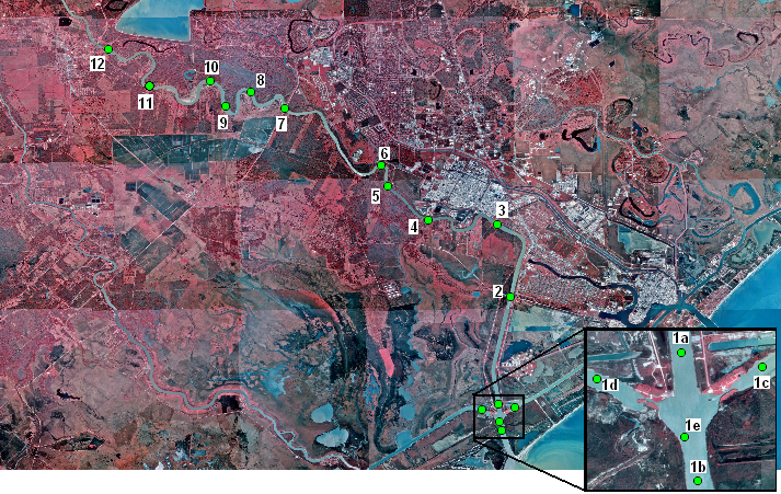
| Name | Site | Latitude (N) | Longitude (W) | Water Quality Data | |||
| GIWW & Brazos River Confluence | 1 | 28° 53.35' | 95° 23.06' | Click for access to an interactive ArcIMS website | |||
| State Highway 36 | 2 | 28° 56.46' | 95° 22.48' | ||||
| Dow Outfall | 3 | 28° 58.39' | 95° 23.09' | ||||
| Old Ferry | 4 | 28° 58.45' | 95° 24.55' | ||||
| Right Bend | 5 | 28° 59.37' | 95° 25.58' | ||||
| Concrete Bunker Intake | 6 | 29° 0.09' | 95° 26.08' | ||||
| Highway 2004 | 7 | 29° 1.37' | 95° 28.36' | ||||
| Forested Bend | 8 | 29° 2.03' | 95° 29.29' | ||||
| 1/2 way to Willow Bend | 9 | 29° 1.40' | 95° 30.8' | ||||
| Willow Bend | 10 | 29° 2.19' | 95° 30.31' | ||||
| Another Bend | 11 | 29° 2.10' | 95° 32.09' | ||||
| Dow Intake | 12 | 29° 3.08' | 95° 33.08' | ||||
For more information, please contact:
Dr. Carla Guthrie, Aquatic Ecologist
Email: Carla.Guthrie@twdb.texas.gov
Surface Water Resources
FAX: (512) 936-0816